|
<< Click to Display Table of Contents >> Manual regularisation |
  
|
|
<< Click to Display Table of Contents >> Manual regularisation |
|
The conceptual basis of manual regularisation is simple. If there are too many parameters to estimate uniquely, then reduce the number of parameters until uniqueness is attained. This path to parameter uniqueness has an intuitive appeal - as does the principal of parsimony and Occam's razor. It is based on the notion that estimation of too many parameters leads to over-fitting, and that over-fitting leads to predictive bias. This is because inestimable parameters, and predictions that depend on them, may be awarded unreasonable values when calibration attempts to solve an inverse problem that is ill-posed or nearly ill-posed. |
Consider a typical groundwater model. Its domain may span a large area. The model may have a single layer; or it may possess multiple layers. The calibration dataset may be comprised of heads in a number of wells, and perhaps inflow to a reach or two of a stream. What is the best way to implement manual regularisation? Usually the first step is to fix some parameters at values that make sense, and then estimate other parameters. The values of estimated parameters then become conditional on the values that are assigned to fixed parameters. Presumably the values that are assigned to fixed parameters are their "most likely" values. That is, these values are at the centres of their respective prior probability distributions. However if these prior probability distributions are broad, then "most likely" does not mean "correct". In fact, "most likely" is probably wrong. When the model is subsequently history-matched, the values awarded to adjustable parameters must then compensate for the erroneous values awarded to fixed parameters in order for model outputs to fit the calibration dataset. Parameter, and possibly predictive, bias become a real possibility. Within the model domain itself, parameter definition may be based on zones of piecewise hydraulic property constancy. Ideally, zonation is based on geology, to the extent that the local geology is known. However if geology-based zonation provides too few parameters to achieve a good fit between model outputs and field measurements, the number of zones must be increased. Maps of model-to-measurement misfit achieved through calibration based on too few zones may guide a modeller in designing new zones. Unfortunately however, under circumstances such as these, zonation does not seem to provide a satisfying description of prevailing hydraulic property heterogeneity. Difficulties in zone definition generally increase with model layer number. Geological information pertaining to deeper model layers may be insufficient to guide a modeller towards the most appropriate locations of zone boundaries. So the locations of these boundaries are often guessed. A wrong guess may not compromise model-to-measurement fit. However it may bias some parameters (and perhaps predictions) as estimated parameter values compensate for wrong choices of parameter boundaries. Zonation definition for aquitards is even more problematical. Aquitard vertical permeabilities may vary greatly in space. Predictions of management interest may be sensitive to these permeabilities. Often little information on these variations is available from drill hole data and geological modelling that is inferred from these data. So while aquitard heterogeneity must be acknowledged, its encapsulation in zones of piecewise constancy does not seem to be geologically reasonable. |
Manual regularisation is rarely the best way to pursue parameter uniqueness when calibrating a groundwater model. Subsurface media are not piecewise homogeneous. If such an assumption is made, the prior probability distribution of model parameters is therefore incorrect. From Bayes equation it follows that the posterior parameter probability distribution will also be incorrect. The chances of predictive bias are therefore high. But it is not just predictive bias that is of concern. If post-calibration uncertainty analysis is based on the same parameters that are used to attain parameter uniqueness, and if most of the uncertainty associated with a prediction of management interest is an outcome of parameter nonuniqueness (as it normally is), then how can this uncertainty be assessed? In fact, it will be underestimated. The outcome of predictive uncertainty under-estimation is decision-support modelling failure. Problems associated with design of an appropriate model zonation scheme are considerable. If a given zonation scheme does not support attainment of a good fit between model outputs and field measurements, this tells the modeller that hydrogeological heterogeneity is not well represented in his/her model. So an extra zone (or two) must be introduced. The mapped geology may provide few clues on where this sharp boundary should be introduced; in fact, often geological considerations suggest that the boundary should not be sharp at all. A modeller must then decide whether it is better to live with model-to-measurement misfit (and therefore deny entry into the modelling process of important information that field measurements host), or to misuse this information by transferring it to parameters that are not designed to receive it, and that are therefore likely to misinterpret it and induce predictive bias. Manual regularisation is an exceedingly subjective process. It requires many personal decisions on parameterisation scheme suitability and model-to-measurement fit suitability. To be sure, construction of a decision support model requires many subjective choices. However these should be avoided when their most likely outcome is the manner in which avoidable suboptimality of the decision-support modelling process will manifest itself.
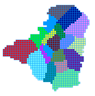
Zones of assumed hydraulic property constancy. |